Monday, October 29, 2007

Ask and ye shall receive


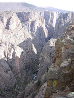
Here are more pictures. Granted, most of them are from the previously featured Black Canyon, but I've been busy as a beaver and haven't gone any place new in the last week.


This is the "painted wall" on the west end of the
canyon.


Here's a view of the Montrose valley - the next valley west of Gunni. The town is about 70 miles away and is totally unremarkable except for...TARGET.

The Gunni MallWart is deeply, deeply depressing. Really, it's better to go without or just find a reason to go to Montrose.

Sunday, October 28, 2007

It's a small town after all

Yesterday, after spending 6 hours navel-gazing about diversity and technology in the classroom, the esteemed faculty were invited to a colleague's house for a Halloween party. Actually, it's a pair of colleagues but only one is in my department. Turns out I should have asked the other one for directions.

As some of you know, the Spudmobile is back with Mr. PotatoHead, so whenever I want to go somewhere, I have to either pop in the "Hiking Boot" attachment (sold separately) or bum a ride. My usual ride is another new faculty member whom I will call Dr. Bones.

By way of giving directions, our host took us to the large window on the eastern end of the Sciences building and waved vaguely towards a brown house up on a ridge. This is the Gunni equivalent of a Somervillite telling you they live in the white frame house near the Dunkin' Donuts (i.e., completely useless).

But we'd teased a couple of other identifying characteristics from our colleague and thought we knew where we were going. The house was, by his reckoning, only a mile from campus. No problemo.

There ought to be a word for the specific kind of lost you are when you know exactly where you are but the place you're looking for is not where it's supposed to be. We drove around a while being that particular kind of lost until we saw a not-at-all brown house not-at-all on a ridge with a bunch of kids out front. Out of desperation, we pulled in, thinking that if it's not the right house they may know how to direct us to their neighbors.

It wasn't, of course, the right house, but the kids go fetch an adult to help us out. And who should the adult be...but a student of mine who had been AWOL for the last couple of days. Student has in fact decided to withdraw, so while Dr. Bones calls the other host to get directions that actually make a lick of sense, I have an incredibly awkward conversation with this poor student who really did not expect to have to explain her life plans to her professor in her driveway in front of her kids and all their friends.

Friday, October 26, 2007


I have been asked to provide a picture of myself. Here I am in the bustling downtown of our podunk, redneck, whitebread, mishugana mountain town.

Actually, Gunni only really qualifies as the last, cowboy hats in fact being large enough to shield one's neck. (As opposed to the seed cap which only shields the upper forehead). And towns with organic bakeries cannot technically be whitebread. Mishugana, which I understand means 'crazy' in Yiddish, is open to interpretation.

Lastly, for you longtime Trey Parker/Matt Stone fans out there - the Community Theatre's Fall production is "Cannibal! The musical".

Although in general I dislike musicals and would rather, well...eat human flesh than have to sit through one, I'm going to make an exception and check this out. The movie is pretty funny, and my heart is as big a baked potato.

Thursday, October 25, 2007

Farther afield


If you head west out of town on 50 you get to the largest body of water in Colorado - the Blue Mesa Reservoir. It's the thrice-dammed Gunnison river which goes on to flow through the Black Canyon of the Gunnison, now a National Park.

Remember, we're west of the continental divide he
re, so rivers flow "down" to the west.


The picture was taken from a nifty little hike just off 50 to this chunk o' geology called the Dillon Pinnacles.

Now that I have geologists as colleagues, I am very nervous about mis-identifying geological features. Better to just be general.


If you keep going west you pass through the Curecanti National recreation area. You can hike down and take a boatride on one of the middle reservoirs. Locals, be warned - the Rangers will try to recruit you to their recreational ice hockey team. The canyon isn't particularly narrow or deep here, but it's still a lovely trip.


Farther west you
can drive along the Southern rim and hop out and take a series of short hikes to overlooks. It's kind of like "hiking sprints" and winds up being much more of a workout than the distance would imply. We're at 8000 ft here...and I'm still not in particularly good shape. (Taking regular walks in the hills...good. Cooking for myself...bad.)


Here Mr. PotatoHead yawps westward into the canyon. The safety fence makes it look less impressive, but it was a very good yawp.


Incidently, only the Southern side of the canyon has overlooks with wimpy safety fences. On the Northern rim you can walk right up to the edge. You'd probably get some darn impressive pictures if you remember to bring your camera.

If I was a real potato head, I supposed I'd have a little divot in my side where the camera could be plugged in so I wouldn't forget it. Or would I have to pop out my eyeballs and stick in the camera (to mimic holding the camera up to take a picture)? Perhaps a better option would be replacing my glasses with the camera, because if I were going to have eyeballs that could be popped in and out I'd definitely spring for a 20/20 vision model.

Golly, this is a long post.
Perhaps I should go grade something now.

Morning walk

The campus is on the Eastern edge both of town and of the basin, and the science building is on the Eastern edge of campus. Very convenient for the hiking trails up into the hills. Since my commute has shrunk to a 5 minute walk, I try to trot up there a few times a week.

If I start getting really homesick, I'll have to record inane cell phone chatter for my ipod and bring along a 'regular' Dunkies coffee to spill on my feet.


This view is of town with the palisades on the other side of the basin. This picture was taken pretty early in October - see the pretty yellow aspens?


These mountains are the West Elks - they run north of town on the west up towards Crested Butte. And yes, they seem to be full of elk. Mmmmmmm....elk.

W mountain

This 'W' on a mountain at the southeast edge of the basin is the largest (and possibly highest) college logo in the world. The students set it on fire on the Friday night before Homecoming every year. Makes for a fun evening as long as the wind doesn't pick up.

Monday, October 22, 2007